( Log In ) Log In is for TREC Teachers & Researchers only
 TREC Virtual Base Camp > Gallery > 2006 Expedition Galleries > Pre-Historical Human-Environment Interactions: Russia
4 Pages  < 1 2 3 4 > < 1 2 3 4 >
|
 |
Volcanoes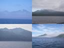 Uploaded by: Misty_Nikula_Ohlsen On: 1155763110 File Size: 8909 Comments: 0 / Views: 1209 Description: Some of the more dramatic volcanoes of the Kuril Islands rising above the water. Clockwise from upper left - Atsonupuri on Itrurup Island, L'Vinaya Past Caldera on Iturup Island, Chirip on Iturup, and Nemo on Onekotan. |
Cruise Track of Gipanis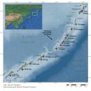 Uploaded by: Janet_Warburton On: 1155674382 File Size: 34564 Comments: 0 / Views: 1274 Description: Map of Kuril Islands with the cruise track of the Gipanis. Red stars and dates correspond to Misty's journal entries and her approximate location. Original map created by the University of Washington for the Kuril Biocomplexity Project. |
Map of Kuril Islands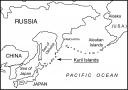 Uploaded by: Janet_Warburton On: 1155674158 File Size: 103463 Comments: 0 / Views: 1158 Description: Location map of Kuril Islands. Map created by the University of Washington, for the Kuril Biocomplexity Project. |
August 12-15 Uploaded by: Misty_Nikula_Ohlsen On: 1155656899 File Size: 30022 Comments: 0 / Views: 921 Description: On the left: Jesse Einhorn (standing in black), Jody Bourgeois (kneeling in yellow) and Colby Phillips (kneeling with blue coat and red hat), along with Malish (orange coat, back to camera), work on exposing the tephra sequence high above a wave-cut platform beach. Behind and far below them (about 90 meters) you can see the black, rocks that have been eroded into a flat platform surface by the wave action. | ||
Boat and Malish Uploaded by: Misty_Nikula_Ohlsen On: 1155656601 File Size: 41203 Comments: 0 / Views: 1097 Description: On the left: The boat loaded with palynology gear and people heads for shore at Kharimkotan. Dr. Valery Shubin is operating the engine, Dr. Pat Anderson, from the University of Washington (and my roommate) is to the right of him and Dr. Anatoly Lozhkin, from the Magadan Institute, is in the front of the boat, facing forward. Also in the boat is Valery Golobtsov, an archaeologist, who is going along to assist with unloading the boat. |
Ryponkicha Uploaded by: Misty_Nikula_Ohlsen On: 1155311004 File Size: 32229 Comments: 0 / Views: 892 Description: On the left: I am laying down into the test pit that we dug on top of the terrace at the northern end of Ryponkicha. We dug about 45 cm into the NE quadrant of the pit and found a midden at the base. This picture was taken as I was trying to do a hurried geological description of the stratigraphy. (Image courtesy of Ben Fitzhugh) |
Screening Deck Uploaded by: Misty_Nikula_Ohlsen On: 1155248759 File Size: 43001 Comments: 0 / Views: 908 Description: On the left: Matt Walsh works on spraying salt water on the midden sample from the Vodopadnaya midden test pit. The small mud balls that were left from the initial screening are being broken up and rinsed so that we can collect all of the smallest bone pieces. |
Snail Midden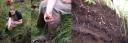 Uploaded by: Misty_Nikula_Ohlsen On: 1155248593 File Size: 55558 Comments: 0 / Views: 908 Description: Caption On the left: Dr. Mike Etnier identifies a large bone found in the midden at Ainu Bay as from an extinct sea lion species. | ||
Misty Working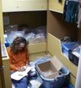 Uploaded by: Misty_Nikula_Ohlsen On: 1155055572 File Size: 67474 Comments: 0 / Views: 954 Description: I am working in the room where all of the archaeological artifacts are being stored. Each items complete provenance has to be recorded on the sample bag, in the artifact book and on an aluminum tag or piece of orange tape that goes into the bag with the item. I never saw Indiana Jones doing this sort of thing! |
Okhotsknichi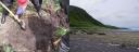 Uploaded by: Misty_Nikula_Ohlsen On: 1154644722 File Size: 66237 Comments: 0 / Views: 925 Description: On the left: Colby and Beth work to fill in the test pit that we dug at Okhotsknichi Creek. We dug two pits nearly a meter wide by a nearly a meter deep and didnt find anything but sand and two possible tephra layers. |
Novokurilskaya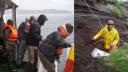 Uploaded by: Misty_Nikula_Ohlsen On: 1154644659 File Size: 72470 Comments: 0 / Views: 923 Description: On the left: Natalia Toropova, Jesse Einhorn, James Taylor and Tetsuya Amano brave the cold and wet as they help to secure the zodiac along the side of the ship and wait to see if they will be going ashore today. |
Urup Os'ma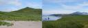 Uploaded by: Misty_Nikula_Ohlsen On: 1154454407 File Size: 34099 Comments: 0 / Views: 984 Description: On the left: The beach terraces that Jody, Beth, Bre and Jesse worked on profiling and excavating at Osma Bay. In this image from the beach you can see three of the four terraces that we measured. Marine terraces are tectonically uplifted beaches, as opposed to beach ridges, which form when the water level moves lower. One of the clues to this is that from the top of each step you could see that the area behind it was flat rather than a trough, like with the beach ridges. | ||
Screening Uploaded by: Misty_Nikula_Ohlsen On: 1154454310 File Size: 45803 Comments: 0 / Views: 988 Description: On the left: Matt Walsh and I work to wash the soil and sand away from a few shovelfuls of dirt from the midden excavation so that we can recover any small bones or artifacts that may be present. |
Hot Springs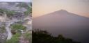 Uploaded by: Misty_Nikula_Ohlsen On: 1154376565 File Size: 39560 Comments: 0 / Views: 853 Description: On the left: The hot spring above Kuril'sk on Iturup Island. You can see the water coming down the hillside -- it spring right out of the rocks further up. You can also see some of the white, red and yellow mineral deposits along the banks. The water is heated underground by volcanic hotspots and then the minerals from the rocks are dissolved into it. As the water begins to cool above ground, the minerals solidify and precipitate out onto the surrounding rocks on the stream banks. (Image courtesy of Mike Etnier) |
Peshenoye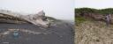 Uploaded by: Misty_Nikula_Ohlsen On: 1154376458 File Size: 47891 Comments: 0 / Views: 948 Description: On the left: A Japanese glass float lying on the beach. Japanese fishermen used these floats for their nets from the early 1900s. Only a few traditional fishermen use these floats now, but hundreds of thousands can be found in large piles on Hokkaido and other islands in Japan as well as washed up on beaches all around the Pacific Ocean. (Image courtesy of Mike Etnier.) |
Gun Turret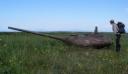 Uploaded by: Misty_Nikula_Ohlsen On: 1154126261 File Size: 68329 Comments: 0 / Views: 957 Description: Jesse Einhorn investigates the WWII gun turret that now is rusting away on the spit that juts out from the south end of Kunashir Island. | ||
Sernovodsk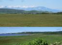 Uploaded by: Misty_Nikula_Ohlsen On: 1154125992 File Size: 42897 Comments: 0 / Views: 836 Description: Image on top: The view from a high spot looking across the low-lying areas toward the lake at Sernovodsk. The mountains rising in the background are on Hokkaido Island, which is the northernmost island of Japan. |
Day 2 Work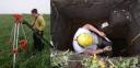 Uploaded by: Misty_Nikula_Ohlsen On: 1153850203 File Size: 59713 Comments: 0 / Views: 933 Description: On the left: Bre MacInnis is working to set up the survey instrument it is on top of the tripod. She will need to level the instrument with the tripod before we can take a measurement. She is taking the scaled rod out of its storage bag. |
Work Site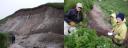 Uploaded by: Misty_Nikula_Ohlsen On: 1153850155 File Size: 51829 Comments: 0 / Views: 972 Description: On the left: Beth is in front of the huge mudflow deposit. The deposit extends from the river bed up to nearly the top of the hillside a height of 20 meters. The darker, reddish brown strip at the top is the 4 m debris flow that we saw in our first excavation. |
Site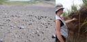 Uploaded by: Misty_Nikula_Ohlsen On: 1153766178 File Size: 44457 Comments: 0 / Views: 841 Description: On the left: The Deflation Lag Deposit site that we first found. All of the rounded rocks are surrounded by bits of stone tools and flakes, broken pieces of pottery and charcoal -- all removed from their original "context" by the removal of the sand and dirt by wind erosion. | ||

4 Pages < 1 2 3 4 >
|
|

|
NSF Acknowledgment & Disclaimer | Time is now: 10th July 2025 - 04:17 AM |
Invision Gallery
2.0.7 © 2025 IPS, Inc.