 |
|
|
| Author |
Message |
Patty_Cie

Joined: 23 Mar 2004
Posts: 87

|
 Posted:
Sat Jun 19, 2004 9:47 pm Posted:
Sat Jun 19, 2004 9:47 pm |
  |
June 11, 2004, Friday
6:00 AM Alaska time
I have been sitting here this morning, recalling my conversation with University of Tennessee (UT) research professors, Jackie Grebmeier and Lee Cooper following yesterday’s teleconference. Jackie is the chief scientist for the Shelf-Basin Interaction (SBI) spring cruises and Lee is the chief scientist for the SBI summer cruises. From my observations, they function like co-chief scientists although during this cruise Jackie has the final responsibilities for the science party, as Lee will in the summer. Theoretically, Lee has the noon to midnight shift and Jackie has the midnight to noon shift. In reality, they both work most of the day and night and sleep very little. As I was interviewing them, it was easy to tell they have worked together for a number of years. The conversation bounced effortlessly from one to the other as they explained Western Arctic Shelf-Basin Interaction’s (SBI) connection to global warming investigation and their individual projects.

Dr. Jackie Grebmeier and Dr. Lee Cooper have studied the Arctic Ocean for over twenty years.
The idea of global warming is not a simple or straightforward. All places on the planet are not experiencing the same environmental changes at the same time. For example, while certain parts of the world are getting warmer (such as the 3-4 degree C temperature rise in the North American Arctic over the last 30-40 years), other places like Labrador and western Greenland have become cooler. Still, even in Greenland, conditions are not the same. At higher elevations, studies show an increase in snow pack, but at sea level, there is evidence the glaciers are retreating.
Currently, sea levels are rising world wide at approximately 2 mm a year. Although it is difficult to exactly measure this small of a change in the world ocean, approximately one millimeter is from the physical expansion of the seawater as it warms. The second millimeter is from an increase in water volume as the northern polar glaciers retreat in areas such as Alaska and parts of Greenland. The SBI scientists are interested in studying the physical and biological impact of these and other environmental changes including how food webs will change in response to changes in sea ice cover.
While global warming has been an intense topic with negative connotations in the media, the actual impacts are still in question. It may be that the environmental change will cause additional upwelling on continental shelves, thereby, escalating production as greater mixing occurs and more nutrients from deep water are added to the water column. On the other hand, the warming may lead to a highly stratified water column. With little or no mixing, the deeper water nutrients would not be available to the phytoplankton, thereby, decreasing the production and possibly forcing a change to the food web.
During their Arctic Ocean studies over the last 20 years, Jackie and Lee have seen trends that seem to indicate a decline in the biomass over the North Bering Sea and Chukchi Sea shelves. Because the Arctic Ocean food chain is so short, declines show quickly. This high sensitivity to ecological change makes the Arctic an excellent study area to help scientists understand and predict what impacts environmental changes may have on the rest of the world.
SBI is an interdisciplinary, collaborative effort to gain further understanding of processes occurring in the western Arctic Ocean. By investigating the biology and chemistry of both the water column and the seafloor, scientists will expand their understanding of the pelagic/benthic coupling. Therefore, SBI includes projects that study the water column (pelagic) and the seafloor (benthic) as well as interactions between the continental shelves and the deep ocean basin. Both Jackie and Lee’s efforts include the benthos and some water column chemistry.
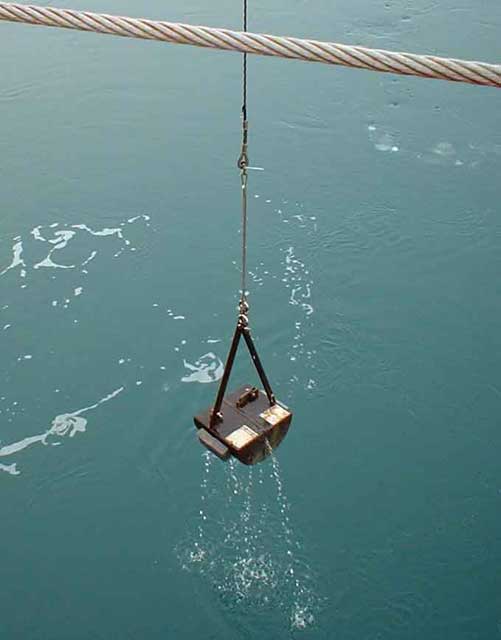
Jackie uses two different sampling devices to gather material from the seafloor. She uses the van Veen grab for population, community structure, and food web studies and the multi-HAPS for metabolism studies. The van Veen grab is metal and designed in two halves that shut together forming a closed container. It is sent to the ocean floor on a winch wire. When it touches the floor, the triggering device is released and the grab bites, removing a 0.1 m2 area of the seabed.

The van Veen Grab is ready to deploy.

When the van Veen Grab reaches the seafloor, it closes quickly and captures a sample.
Jackie takes five grabs at each benthic station. One grab is for chemical and food web analysis. Her lead technician, Ari Balsom and graduate student, Rebecca Pirtle-Levy, take samples for chlorophyll, total organic carbon, carbon-13/12 ratios, high performance liquid chromatography (HPLC) and radioisotopes. The remaining four grabs are for quantitative population and community structure analysis. Each grab sample is placed inside a separate wooden box with a screened bottom. The mud is washed away from the organisms using a gentle stream of seawater. The clean animals are put into a 10 percent, buffered formalin solution and shipped back to UT at the end of cruise. During the winter, the animals are sorted and identified.

The sediment must be washed from the organisms.
A HAPS corer is a single tube that is sent to the benthos on a winch wire. When it reaches the bottom, it sinks into the seafloor, closes and traps an undisturbed core of sediment topped by a water layer. It takes a long time to send equipment to the ocean floor at deep stations. Being practical, Jackie designed a multi-HAPS corer. Her design takes four cores at the same time. In this way, she saves wire time and can do replicate experiments to further validate her data.

Jackie wires the multi-HAPS corer so that it does not trigger before reaching the seafloor.
Jackie uses two cores for respiration experiments. The cores are immediately put into a dark, -1.6 degree Celsius cold room to simulate the natural environment. Oxygen, nutrients, carbon dioxide and dissolved organic carbon measurements from the water lying over the sediment are taken before and after a 24-hour incubation period. At the conclusion of the experiment, the cores are washed and the organisms preserved for population and community structure analysis at UT.
The third core is used for chemical vertical depth profiling. Ari and Rebecca slice it into sections. Starting at the top of the core they take one centimeter slices to the four centimeter depth, two centimeter slices to the 20 cm depth and 4 cm slices to the end of the core. A chlorophyll sample is taken from each section. To extract the chlorophyll from the sediments, acetone is added to the sample and it is allowed to sit in the dark for 12 hours. At the end of 12 hours, the chlorophyll levels are measured using a fluorometer. The remainder of each sliced section is put into a separate can, sealed and frozen. The cans will be sent to UT at the end of the cruise for gamma ray spectrometer analysis of the radioactive isotopes cesium-137, beryllium-7, and lead-210, which gives information on how fast and where materials fall out on the seafloor. If needed, the last core is available for Rebecca to gather data for her master thesis on sediment chlorophyll distribution. Sometimes it is given to Brad Moran’s group to do thorium analysis.

Ari and Rebecca slice cores for vertical depth profiling.
Lee is also investigating arctic water origins to study the transport systems within the Arctic Ocean. The Arctic is the smallest ocean body and perhaps the most interesting. Proportionally, it has the largest amount of productive continental shelf with multiple water sources. The bulk of the Arctic’s inflowing seawater comes from the salty, relatively warm, nutrient-poor Atlantic. About 10,000 years ago, water levels rose flooding the North American/Russian land bridge and forming the Bering Strait. The Strait provides a surging pathway for the cold, nutrient-rich Pacific water entrance into the Arctic region. Due to their differences in temperature and salinity, the Atlantic and Pacific waters have different densities. The different densities cause a layering effect known as a thermocline (for temperature) and a halocline (for salinity). Furthermore, the Arctic has a tremendous amount of non-saline influence; both from river runoff and snow/sea ice melt creating a less dense, freshwater cap.
Lee gathers seawater samples from the CTD at different depths and snow off the ice floes. He collects additional samples from rivers throughout the Arctic region for a reference collection. Each water source is isotopically different. By measuring the ratio of oxygen-18 to oxygen-16, Lee is able to differentiate the Atlantic from Pacific seawater, the different river waters, melted sea ice and the atmospheric water (precipitation) that enter the Arctic Ocean. One of the advantages of oxygen-18/oxygen-16 ratios is that it is not affected by sea ice formations and melt as much as salinity is. So in combination with the other water chemistry measurements (e.g. nutrients, terrestrial markers), these stable isotope ratios can provide information about where the water originated, where it has traveled and how long it has been part of the Arctic Ocean. With this information, Lee gains further understanding how the different water masses move within and throughout the Arctic water column.

Lee can frequently be found entering data. The box next to his computer contains his water samples.
To see photographs taken by Steve Roberts of UCAR/JOSS, click here. |
|
|
    |
 |
|
|
|
View next topic
View previous topic
You cannot post new topics in this forum
You cannot reply to topics in this forum
You cannot edit your posts in this forum
You cannot delete your posts in this forum
You cannot vote in polls in this forum
You cannot attach files in this forum
You can download files in this forum
|
Powered by phpBB 2.0.11
© 2001, 2002 phpBB Group :: FI Theme ::
All times are GMT
| |
