( Log In ) Log In is for TREC Teachers & Researchers only
  |
| Dena_Rosenberger |
 Dec 20 2005, 09:15 AM Dec 20 2005, 09:15 AM
Post
#1
|
 TREC Teacher    Group: TREC Team Posts: 96 Joined: 1-November 05 Member No.: 22 |
Bye, Bye, Penguins
20 December, 2005 For those interested in things Antarctic, check out the weekly Antarctic newspaper at http://AntarcticSun.usap.gov Hello from the Ice! For additional Antarctic pics, check out the Gallery. Whereís Rosenberger? McMurdo Station, Ross Island, Antarctica Last night after dinner, we walked up Observation (Ob) Hill next to McMurdo. This is one of the few walks you can do here without checking out a radio at the Firehouse. The wind was really blowing but Markus and Kaelin walked all the way out to the point facing South where I took their picture. It is a very desolate and beautiful landscape. 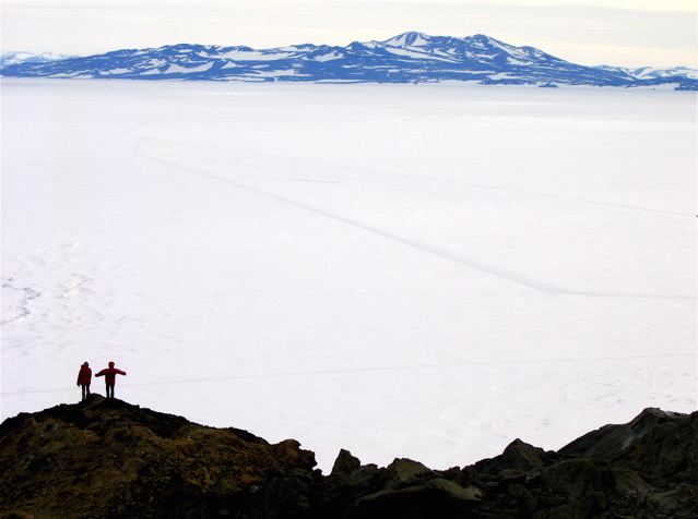 Across the ice you can see a road stretching into the distance toward Black Island. This road is the start of the $20 million South Pole Traverse project, which aims to build a road from McMurdo Station to the South Pole so that heavy equipment can transport supplies rather than having to fly everything in to the Pole. This large train of farm tractors, blasting equipment, and supply trains is supposed to reach the Pole after a thousand mile journey by the end of this Antarctic summer (March, 2006). The project, started in 2002, is full of logistical nightmares since they have to cross huge crevasse fields and shifting ice that moves as much as a meter per day. Iím not sure a permanent road is that good of an idea. To read more about this project, see the Antarctic Sun article at: http://antarcticsun.usap.gov/oldissues2002...3/traverse.html Well, we have to say goodbye to the Adelie penguins at Pony Lake. The deep snow cover there coupled with the lack of melting has completely thwarted our attempts to draw a large quantity of liquid water out of the lake. Last year when this project was started, the lake was mostly ice-free by mid-December: 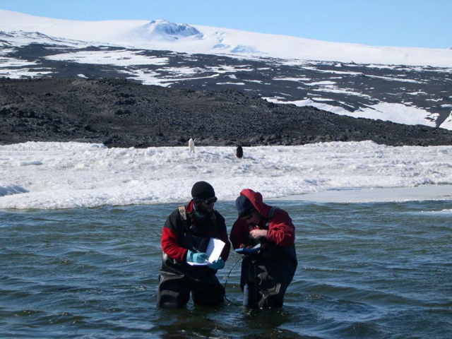 Coring last year, November 15:  Coring this year, November 18: 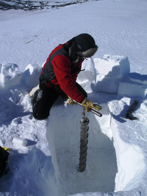 Yesterday, Christine, Yo, and Chris flew to Pony Lake by helicopter so that they could assess the situation with Yo, since Christine is leaving. This is a photo of Pony Lake from the air. This big rocky point is called Cape Royds, and at the height of summer, it will be a rocky peninsula sticking out into the water of McMurdo Sound. The squiggly lines are huge cracks in the sea ice. Pony Lake is right about in the middle of the picture, mostly covered by snow except for a small patch of water on the left. The penguin rookery is situated near the open patch of water. You can even see the remains of our square fortress that we dug in an attempt to clear off the deep snow from the lake! Pony Lake from the air:  A curious Adelie penguin came by to say hello and goodbye: 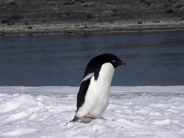 These penguins are returning to Pony Lake from a trip to open water or a hole in the ice to get fish to eat. They will feed their chick at Pony Lake with regurgitated fish from these trips. The pushed up pressure ridge shows where the big cracks are in the sea ice that we saw from the air.  After visiting Pony Lake, they flew to another lake that is actually on the Antarctic continent, rather than on Ross Island where we have been working. They will take some water samples here to see if it has enough Dissolved Organic Matter (DOM) for our purposes. This lake, Lake Fryxell, is very different from Pony Lake. It is in an area of the continent called the Dry Valleys, part of the 2% of Antarctica that is not ice-covered. This lake is HUGE compared to Pony and, even though it has ice on top, it is very deep and has a lot of liquid water under the ice. This lake is about 2 kilometers wide by 5 kilometers long and, sadly, no penguins. This week, we will be preparing to move our operations to this lake to collect the water if everything goes well. Lake Fryxell in the Dry Valleys: 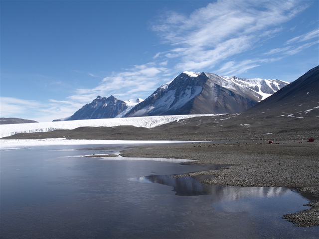 Did you know? The first person to officially sight the Antarctic continent was Fabian von Bellingshausen, a captain in the Russian Imperial Navy. Although he didnít realize the importance of his discovery, he made note of ďan icefield covered with small hillocks,Ē the weather conditions, and the position of the ship in his log. The date was January 27, 1820. Despite this discovery, it was almost 120 years later with the start of the Cold War before the Soviet Union became interested in asserting its right to authority in Antarctica. (Lonely Planet - Antarctica) Current Conditions at McMurdo Station It has been snowing most of the day, but since it is right at the freezing point, it is mostly not sticking. A low pressure system over the Ross Ice Shelf will continue to bring wind and snow for the next two days. I donít think that any flights will be leaving soon, so Christine may be stuck here. Right now: Half-mile visibility Pressure: 29.385 inHg Winds from N at 9 knots Temperature: 32 oF/0 oC with wind chill: 18 F/ -8 C Sunset: February 20 at 1:38 am |
| Janet_Warburton |
 Dec 20 2005, 07:23 PM Dec 20 2005, 07:23 PM
Post
#2
|
 Project Manager Group: ARCUS Posts: 146 Joined: 29-April 05 From: Fairbanks, Alaska Member No.: 13 |
Hi Dena -
We will miss the penguins too! They are just too cute! But, I must say that the lake you will be working out of is very beautiful with those mountains! And it looks like some good places to go walking! Janet |
| Edie Cleves |
 Dec 20 2005, 11:57 PM Dec 20 2005, 11:57 PM
Post
#3
|
|
Unregistered |
QUOTE(Dena_Rosenberger @ Dec 20 2005, 09:15 AM) Bye, Bye, Penguins 20 December, 2005 For those interested in things Antarctic, check out the weekly Antarctic newspaper at http://AntarcticSun.usap.gov Hello from the Ice! For additional Antarctic pics, check out the Gallery. Whereís Rosenberger? McMurdo Station, Ross Island, Antarctica Last night after dinner, we walked up Observation (Ob) Hill next to McMurdo. This is one of the few walks you can do here without checking out a radio at the Firehouse. The wind was really blowing but Markus and Kaelin walked all the way out to the point facing South where I took their picture. It is a very desolate and beautiful landscape.  Across the ice you can see a road stretching into the distance toward Black Island. This road is the start of the $20 million South Pole Traverse project, which aims to build a road from McMurdo Station to the South Pole so that heavy equipment can transport supplies rather than having to fly everything in to the Pole. This large train of farm tractors, blasting equipment, and supply trains is supposed to reach the Pole after a thousand mile journey by the end of this Antarctic summer (March, 2006). The project, started in 2002, is full of logistical nightmares since they have to cross huge crevasse fields and shifting ice that moves as much as a meter per day. Iím not sure a permanent road is that good of an idea. To read more about this project, see the Antarctic Sun article at: http://antarcticsun.usap.gov/oldissues2002...3/traverse.html Well, we have to say goodbye to the Adelie penguins at Pony Lake. The deep snow cover there coupled with the lack of melting has completely thwarted our attempts to draw a large quantity of liquid water out of the lake. Last year when this project was started, the lake was mostly ice-free by mid-December:  Coring last year, November 15:  Coring this year, November 18:  Yesterday, Christine, Yo, and Chris flew to Pony Lake by helicopter so that they could assess the situation with Yo, since Christine is leaving. This is a photo of Pony Lake from the air. This big rocky point is called Cape Royds, and at the height of summer, it will be a rocky peninsula sticking out into the water of McMurdo Sound. The squiggly lines are huge cracks in the sea ice. Pony Lake is right about in the middle of the picture, mostly covered by snow except for a small patch of water on the left. The penguin rookery is situated near the open patch of water. You can even see the remains of our square fortress that we dug in an attempt to clear off the deep snow from the lake! Pony Lake from the air:  A curious Adelie penguin came by to say hello and goodbye:  These penguins are returning to Pony Lake from a trip to open water or a hole in the ice to get fish to eat. They will feed their chick at Pony Lake with regurgitated fish from these trips. The pushed up pressure ridge shows where the big cracks are in the sea ice that we saw from the air.  After visiting Pony Lake, they flew to another lake that is actually on the Antarctic continent, rather than on Ross Island where we have been working. They will take some water samples here to see if it has enough Dissolved Organic Matter (DOM) for our purposes. This lake, Lake Fryxell, is very different from Pony Lake. It is in an area of the continent called the Dry Valleys, part of the 2% of Antarctica that is not ice-covered. This lake is HUGE compared to Pony and, even though it has ice on top, it is very deep and has a lot of liquid water under the ice. This lake is about 2 kilometers wide by 5 kilometers long and, sadly, no penguins. This week, we will be preparing to move our operations to this lake to collect the water if everything goes well. Lake Fryxell in the Dry Valleys:  Did you know? The first person to officially sight the Antarctic continent was Fabian von Bellingshausen, a captain in the Russian Imperial Navy. Although he didnít realize the importance of his discovery, he made note of ďan icefield covered with small hillocks,Ē the weather conditions, and the position of the ship in his log. The date was January 27, 1820. Despite this discovery, it was almost 120 years later with the start of the Cold War before the Soviet Union became interested in asserting its right to authority in Antarctica. (Lonely Planet - Antarctica) Current Conditions at McMurdo Station It has been snowing most of the day, but since it is right at the freezing point, it is mostly not sticking. A low pressure system over the Ross Ice Shelf will continue to bring wind and snow for the next two days. I donít think that any flights will be leaving soon, so Christine may be stuck here. Right now: Half-mile visibility Pressure: 29.385 inHg Winds from N at 9 knots Temperature: 32 oF/0 oC with wind chill: 18 F/ -8 C Sunset: February 20 at 1:38 am |
| Guest |
 Dec 20 2005, 11:59 PM Dec 20 2005, 11:59 PM
Post
#4
|
|
Unregistered |
|
| Edie Cleves |
 Dec 21 2005, 12:07 AM Dec 21 2005, 12:07 AM
Post
#5
|
|
Unregistered |
QUOTE(Dena_Rosenberger @ Dec 20 2005, 09:15 AM) Bye, Bye, Penguins 20 December, 2005 For those interested in things Antarctic, check out the weekly Antarctic newspaper at http://AntarcticSun.usap.gov Hello from the Ice! For additional Antarctic pics, check out the Gallery. Whereís Rosenberger? McMurdo Station, Ross Island, Antarctica Last night after dinner, we walked up Observation (Ob) Hill next to McMurdo. This is one of the few walks you can do here without checking out a radio at the Firehouse. The wind was really blowing but Markus and Kaelin walked all the way out to the point facing South where I took their picture. It is a very desolate and beautiful landscape. Hi Dena, I"m at Gwens' and reading your fantastic journal. Photos' are beautiful. Missed you at my Xmas Party. Had it catered, which I loved. No time in the kitchen--which I also loved. All of Daves' family came , 20 in total. Dave and I will spend a quiet Xmas in PS. Bill seems to be doing OK, but I know he really misses you and is taking good care of your cats. Thank you for the lovely note cards. Much love, Edie  Across the ice you can see a road stretching into the distance toward Black Island. This road is the start of the $20 million South Pole Traverse project, which aims to build a road from McMurdo Station to the South Pole so that heavy equipment can transport supplies rather than having to fly everything in to the Pole. This large train of farm tractors, blasting equipment, and supply trains is supposed to reach the Pole after a thousand mile journey by the end of this Antarctic summer (March, 2006). The project, started in 2002, is full of logistical nightmares since they have to cross huge crevasse fields and shifting ice that moves as much as a meter per day. Iím not sure a permanent road is that good of an idea. To read more about this project, see the Antarctic Sun article at: http://antarcticsun.usap.gov/oldissues2002...3/traverse.html Well, we have to say goodbye to the Adelie penguins at Pony Lake. The deep snow cover there coupled with the lack of melting has completely thwarted our attempts to draw a large quantity of liquid water out of the lake. Last year when this project was started, the lake was mostly ice-free by mid-December:  Coring last year, November 15:  Coring this year, November 18:  Yesterday, Christine, Yo, and Chris flew to Pony Lake by helicopter so that they could assess the situation with Yo, since Christine is leaving. This is a photo of Pony Lake from the air. This big rocky point is called Cape Royds, and at the height of summer, it will be a rocky peninsula sticking out into the water of McMurdo Sound. The squiggly lines are huge cracks in the sea ice. Pony Lake is right about in the middle of the picture, mostly covered by snow except for a small patch of water on the left. The penguin rookery is situated near the open patch of water. You can even see the remains of our square fortress that we dug in an attempt to clear off the deep snow from the lake! Pony Lake from the air:  A curious Adelie penguin came by to say hello and goodbye:  These penguins are returning to Pony Lake from a trip to open water or a hole in the ice to get fish to eat. They will feed their chick at Pony Lake with regurgitated fish from these trips. The pushed up pressure ridge shows where the big cracks are in the sea ice that we saw from the air.  After visiting Pony Lake, they flew to another lake that is actually on the Antarctic continent, rather than on Ross Island where we have been working. They will take some water samples here to see if it has enough Dissolved Organic Matter (DOM) for our purposes. This lake, Lake Fryxell, is very different from Pony Lake. It is in an area of the continent called the Dry Valleys, part of the 2% of Antarctica that is not ice-covered. This lake is HUGE compared to Pony and, even though it has ice on top, it is very deep and has a lot of liquid water under the ice. This lake is about 2 kilometers wide by 5 kilometers long and, sadly, no penguins. This week, we will be preparing to move our operations to this lake to collect the water if everything goes well. Lake Fryxell in the Dry Valleys:  Did you know? The first person to officially sight the Antarctic continent was Fabian von Bellingshausen, a captain in the Russian Imperial Navy. Although he didnít realize the importance of his discovery, he made note of ďan icefield covered with small hillocks,Ē the weather conditions, and the position of the ship in his log. The date was January 27, 1820. Despite this discovery, it was almost 120 years later with the start of the Cold War before the Soviet Union became interested in asserting its right to authority in Antarctica. (Lonely Planet - Antarctica) Current Conditions at McMurdo Station It has been snowing most of the day, but since it is right at the freezing point, it is mostly not sticking. A low pressure system over the Ross Ice Shelf will continue to bring wind and snow for the next two days. I donít think that any flights will be leaving soon, so Christine may be stuck here. Right now: Half-mile visibility Pressure: 29.385 inHg Winds from N at 9 knots Temperature: 32 oF/0 oC with wind chill: 18 F/ -8 C Sunset: February 20 at 1:38 am |
  |
1 User(s) are reading this topic (1 Guests and 0 Anonymous Users)
0 Members:

|
NSF Acknowledgment & Disclaimer | Time is now: 31st October 2024 - 05:22 AM |
Invision Power Board
v2.1.7 © 2024 IPS, Inc.


