( Log In ) Log In is for TREC Teachers & Researchers only
  |
| Betty_Carvellas |
 Jul 11 2005, 04:45 PM Jul 11 2005, 04:45 PM
Post
#1
|
 TEA Teacher    Group: TEA Teacher Posts: 41 Joined: 6-July 05 Member No.: 20 |
July 9 - 2005
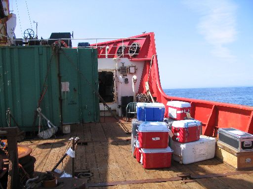
We sailed this morning shortly after 8 AM. Soon after, the serious business of unpacking began. Most of the science equipment had been shipped ahead of time or stored on board from last summer's cruise. It all needed to be taken out of storage, unpacked, and set up in the upper lab, on deck, or in the portable lab on the bow. Although the science crew is small, there's an amazing amount of equipment necessary to support the work that goes on during the 2 weeks of the cruise. And, although the lab space is excellent, it's compact, and the lab must be set up to accommodate not only the equipment, but the scientists who work in the lab. Check out the picture of the lab during set up and the one of just a few of the many boxes set out on deck waiting to be unpacked and sorted.   While many of us were working on deck, we heard the announcement that whales had been sighted off the port side. Sure enough, there was a small group of orcas ("killer" whales) alongside the ship, close enough to see well even without binoculars. They were easily identified by their narrow, triangular dorsal fin. Right after lunch, we heard the alarm indicating a safety drill. We all collected our jackets and carried them to our assigned stations. If you check out the picture, you'll see that the reflectors work very well! Safety is always a primary concern while out at sea, and the drills are a reminder not to take ship board life for granted.  Because I'm responsible for daily journals, I've brought my laptop on board and it's set up in my room. Gerald Rohatensky, the ship's computer specialist, not only set it up but added a great GPS program that allows me to track the ship's movements. As I write this at 7 PM Pacific Time, our latitude is 57 degrees, 7 minutes N and our longitude is 150 degrees, 57 minutes W. If you check the coordinates on a map, you'll see that we are southeast of the island of Kodiak. Today's science work consisted of water sampling only. Our benthic work will begin as soon as we go through Unimak Pass into the Bering Sea. |
  |
2 User(s) are reading this topic (2 Guests and 0 Anonymous Users)
0 Members:

|
NSF Acknowledgment & Disclaimer | Time is now: 18th November 2024 - 05:23 AM |
Invision Power Board
v2.1.7 © 2024 IPS, Inc.


