( Log In ) Log In is for TREC Teachers & Researchers only
  |
| Ute_Kaden |
 Sep 22 2005, 09:31 PM Sep 22 2005, 09:31 PM
Post
#1
|
 TREC Teacher    Group: TREC Team Posts: 203 Joined: 27-April 05 Member No.: 10 |
Powering South
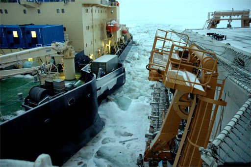
9-21-05 We are using a lot of power and going nowhere Ship Position at 2005/09/21 11:34:01 UTC Longitude: 45 9.001 E Latitude: 85 15.540 N Heavy ice conditions are still prevailing. HEALY and ODEN fighting their way South  Ice edge visible about 200 nautical miles south The ancient Greeks regarded the known world as composed of four elements: earth, air, fire, and water. If they had known of the Arctic, they would undoubtedly have added a fifth element, ice. Last night was comparable to an ongoing earthquake. The ship vibrated, ice hit the hulls left and right ping- ponging us between the pressure ridges. I spent 2 hours in the Aloft Conn to watch the Captain Dan Oliver and LCTR John Reeves driving the ship.  LCDR John Reeves and Captain Dan Oliver at the ships controls driving Backing and Ramming, watching the speed, the heading, the rpm of the engines, the position of the two rudders, Captain Dan Oliver pushed the Healy hard. He looked very concentrated- concerned and pointed to the heavy, thick ice around us. No relieve inside. Satellite photos show the ice edge is 200 nm south. That does not sound very far away. However, we cannot go in a straight line because of the ice conditions and our average speed is at best 2 knots. That amounts to +4 days until we reach the ice edge under current conditions. The ice started growing according to the satellite images and it is dark at the bridge after sunset. Decks are frozen and outside temperatures are dropping. The web of meltponds we saw earlier in our journey is gone.  In one sentence, winter is coming. “Let’s get out of here”, is the saying onboard, followed by ideas what to do first in Tromso, Norway. People would like to go shopping, walk more than 420 ft (128 m) in one direction, hit a pub to have a beer and see something else besides ice. Others joke around like, “Please tell the guys when they drop the food for us sitting here all winter frozen in to include my 1GB switch for the computer”. Around 23:00 the word spread that the ODEN is very close to us, Holy cow… very, very close (-5m). The two ships were breaking ice next to each other and got punched in by the ice. It is very difficult to control the heading when the ship has a pressure ridge against the side. The ship simply bounces off. Remember physics one to one, Newton’s First Law -An object in motion tends to stay in motion… and we have a lot of inertia (mass). The photos show the close positions of the ships.  Oden & Healy are very, very close  Close call! Well, the situation got resolved and we are on our way South. We are all optimists, the ships are strong and the crew is working hard to fix problems quickly. Engines are running full power and the props are turning. Splendor and surprises, arctic nature in all forms. Thus, I still can stand for hours at the bridge admiring the frozen, hostile beauty around me.  We get sun rise and sun sets now . This one is a sun rise. Best regards , Ute Kaden Vocabulary Pressure Ridge - jumbled ice block piles Drifting ice floes collide, the edge of one rides up over another, breaking into thousands of pieces creating ice piles. Thickened ridges sink somewhat, forming inverted keels on the bottom of the pack. Those areas are very thick (we measured one +45 ft) and hard to break for the HEALY. We try to avoid pressure ridges, which is not always possible.  We look for open water in the ice Polynyas - Polynyas are big, long lasting open water areas in the ice and important in the lives of marine mammals and sea birds Leads - long open cracks in the sea ice. Sometimes miles long and navigable by boats Both polynyas and leads are highly desirable for our navigation toward South. We have sometimes beautiful leads. They are just not going south! (photo) |
  |
1 User(s) are reading this topic (1 Guests and 0 Anonymous Users)
0 Members:

|
NSF Acknowledgment & Disclaimer | Time is now: 19th November 2024 - 06:27 AM |
Invision Power Board
v2.1.7 © 2024 IPS, Inc.


